


-
Le complot
Tout y est dit. C'est un rappel, nécessaire.
http://www.incapabledesetaire.com/edito/barbares.pdf
Cela a été confirmé par un Président US, le plus célèbre.
-
Commentaires
12neoVendredi 29 Mai 2015 à 16:157.0 magnitude earthquake strikes off southwest coast of Alaska
et la CIA qui ne partagera plus ces infos
avec les scientifiques sur le climat :

" L'arrêt d'un programme qui a commencé il ya près d'un quart de siècle, la Central Intelligence Agency (CIA) a décidé d'arrêter le partage des informations classifiées qu'elle recueille sur l'océan et l'atmosphère avec les scientifiques qui étudient le changement climatique"
on se demande bien pourquoi hein ...
 Posted in Dormant fault activation, Earth Changes, Earth Watch, Earthquake Omens?, High-risk potential hazard zone, Lithosphere collapse & fisssure, Potential Earthchange hotspot, Prophecies referenced, Seismic tremors, Signs of Magnetic Field weakening, Tectonic plate movement, Time - Event Acceleration, Volcano Watch Leave a comment
60: Japan’s Mount Shindake volcano erupts without warning on Kuchinoerabu Island; evacuation underway
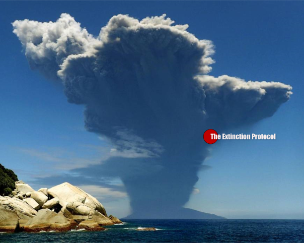
May 2015 – JAPAN – A volcano exploded into life Friday morning on lightly populated Kuchinoerabu Island in Kagoshima Prefecture, sending smoke and ash soaring into the sky. Authorities ordered residents and visitors to evacuate. The 9:59 a.m. “explosive” eruption of the 650-meter Mount Shindake, the main peak on the island, resulted in a plume over 9 km high and a pyroclastic flow which reached the coast, the Japan Meteorological Agency said. All 137 islanders were confirmed safe, including a 72-year-old man who received a burn to his forehead but was able to walk unaided, the Fire and Disaster Management Agency and local authorities said. Residents and visitors on Kuchinoerabu were expected to be evacuated by ferry and coast guard vessel to the nearby island of Yakushima by Friday evening, Yakushima town office said. The island 100 km south of Kyushu is usually reachable only by two ferry routes. Prime Minister Shinzo Abe told reporters, “I have instructed the relevant personnel to do all they can to ensure the safety of islanders.”
A weather agency official told a news conference that there is a risk of a second eruption and associated pyroclastic flows. So far, he said, the pyroclastic flows had not struck the populated Maeda district. Located about 100 km south of the southern tip of Kyushu, Kuchinoerabu has only about 100 full-time residents. Some of those believed to have been present at the time were short-term visitors. The prefectural government said 141 people in all, from 78 families, were required to evacuate. The evacuation warning came after the weather agency upgraded its alert for the island to the highest level of 5, up from the previous level of 3, which imposed limits on climbing the volcano. The prime minister’s office in Tokyo set up a response team at its crisis management center, and the Japan Coast Guard dispatched a large patrol ship to the area. Kuchinoerabu has repeatedly witnessed eruptions and earthquakes, some of them deadly. Mount Shindake erupted in 1841, destroying villages and claiming many lives, while a series of eruptions from late 1933 to early 1934 left eight people dead and 26 injured.
Until Friday, the volcano’s most recent eruption had been on Aug. 3 last year. That eruption prompted 87 people, including some individuals visiting on business, to leave the island the following day. Experts had recorded unusual activity for about a decade leading up to last year’s eruption, and the latest blast could be a relatively large, prolonged one, said Associate Professor Ryusuke Imura of Kagoshima University. Meanwhile, the eruption on Sept. 27 last year of Mount Ontake in central Japan was the nation’s worst postwar volcanic disaster, claiming the lives of hikers near the summit. Fifty-seven people were confirmed dead, but six individuals remain missing, presumed buried under ash and rock.
The hot-spring district of Mount Hakone near Tokyo has seen its ground level rise by up to 15 cm in two weeks this month, as sulfurous steam gushes from vents in the mountain’s flank. Kagoshima Prefecture’s Mount Sakurajima erupted explosively in August 2013, unleashing a plume that reached an altitude of 5 km. The same mountain had 178 small eruptions in March alone and last week one resulted in a plume 4.3 km high.60: Japan’s Mount Shindake volcano erupts on Kuchinoerabu Island. –Japan Times
contribution Lisa M.
 Posted in Black Swan Event, Earth Changes, Earth Watch, Electric power disruption & grid failure, Environmental Threat, High-risk potential hazard zone, Human behavioral change after disaster, Infrastructure collapse, New volcanic activity, Potential Earthchange hotspot, Seismic tremors, Signs of Magnetic Field weakening, Time - Event Acceleration, Volcanic Ash, Volcanic Eruption, Volcanic gas emissions, Volcano unrest, Volcano Watch 2 Comments
Indonesia’s Mt. Sinabung volcano ceaseless eruptions for 5 years – driving some local residents to mental institutions

May 2015 – INDONESIA – Monitoring officials have warned residents to remain alert as Mount Sinabung in North Sumatra continues with intense volcanic activity. A local chief reported that ongoing eruptions had taken a mental toll on residents, with two people being sent to mental institutions. The volcano erupted twice early on Wednesday, at 1:21 a.m. and 3:30 a.m., and sent hot clouds southward. The Sinabung observation station recorded at least 87 tectonic quakes and lava flow from 12 a.m. to 12 p.m. Observation station staff member Deri Alhidayat said the volcanic intensity over the past few days had shown a significant increase, evident from the tectonic quakes occurring thus far. “Tectonic shock waves have been detected almost every day. As many as 20 tectonic and volcanic quakes have taken place today alone,” said Deri on Wednesday. He added the eruptions were expected to continue for a long time.
He urged residents living around the mountain to raise their awareness until the government issued an official announcement on the volcano’s status. Residents in Karo regency, especially those living around the volcano, are said to be depressed as the volcano has continued to erupt for almost five years with no sign of stopping. Pelin Sembiring, the chief of Guru Kinayan village, which is also affected by the eruption, said many residents had suffered from depression from the impacts of the eruptions. Two of his residents had to be treated at the Simalingkar mental hospital in Medan, North Sumatra, for severe depression as all their belongings had been destroyed and their farms, which they relied upon as a source of income, had been damaged by volcanic ash and pyroclastic flows. “Many residents are mentally depressed because they couldn’t stand facing the impacts of the eruption disaster which prevails up until now,” said Pelin.
Pelin also complained about a lack of government attention for victims, who have to fend for themselves to survive. “It has already been nine months since we, from seven relocated villages, have not received living allowances,” said Pelin, adding the last time they had received living allowances was in August 2014. Each of the victims was supposed to receive Rp 6,000 (50 US cents) in addition to 0.4 kilograms of rice daily. North Sumatra provincial council deputy speaker Ruben Tarigan, a Karo community figure, expressed concern over the lack of attention from the government. “This year, the North Sumatra provincial administration only earmarked Rp 1.5 billion to deal with eruption victims,” said Ruben. Karo Regent Terkelin Brahmana said the budget for disaster mitigation this year was smaller compared to last year. “Last year, the Karo regency administration allocated Rp 12 billion to deal with eruption victims, but the amount dropped to Rp 3 billion this year,” said Terkelin.
Terkelin acknowledged that the budget for eruption victims was smaller this year, but would increase next year. Terkelin said he and Vice Governor Erry Nuradi met with National Disaster Mitigation Agency officials a few days ago in Jakarta and discussed victim handling. In the meeting, Terkelin said, he submitted a budget of Rp 6.9 trillion to the central government for the overall management of the Mt. Sinabung eruption disaster. Since an eruption in September 2013, Mt. Sinabung has never entirely stopped its activity. Thousands of residents moved away at that time, only returning home last month after the volcano showed decreased activity. The eruptions have killed at least 17 people and destroyed thousands of houses and hectares of farmland. –Jakarta Post
Posted in Black Swan Event, Civilizations unraveling, Dormant fault activation, Earth Changes, Earth Watch, Earthquake Omens?, Environmental Threat, Harmonic tremor swarm, Health guideliness issued, High-risk potential hazard zone, Human behavioral change after disaster, Infrastructure collapse, Magma Plume activity, Potential Earthchange hotspot, Prophecies referenced, Seismic tremors, Signs of Magnetic Field weakening, Tectonic plate movement, Time - Event Acceleration, Volcanic Ash, Volcanic Eruption, Volcanic gas emissions, Volcano unrest, Volcano Watch 1 CommentTelica volcano shaken by explosive eruption – ejects ash cloud 3 km high

May 2015 – NICARAGUA – After a week of calm, a new phase of explosive activity occurred yesterday at the volcano, beginning with a moderately large explosion at 12:02 local time. An ash plume rose approx. 3 km above the summit: Several smaller explosions and phases of calm ash venting followed this event. Ash falls were noted in up to 15 km distance to the SW, in areas of the villages Posolega and Quezalguaque.
So far it is unclear whether the explosions are the result of phreatic or hydrothermal activity, i.e. caused by pressurized fluids in the shallow hydrothermal system, or whether they are result of new magma reaching the surface.
For now, INETER has not found evidence of fresh magmatic material in the deposits of the explosions – all ash and blocks are fragmented older rocks from near the surface – and the accompanying seismicity has been very shallow. This would favor the first scenario. –Volcano Discovery
Posted in Dormant fault activation, Earth Changes, Earth Watch, Earthquake Omens?, Environmental Threat, High-risk potential hazard zone, Potential Earthchange hotspot, Prophecies referenced, Seismic tremors, Signs of Magnetic Field weakening, Tectonic plate movement, Time - Event Acceleration, Volcanic Ash, Volcanic gas emissions, Volcano unrest, Volcano Watch 1 CommentWhat would happen if the Yellowstone supervolcano erupted?
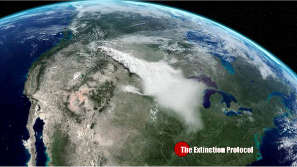
May 2015 – YELLOWSTONE – If Yellowstone had a super eruption right now; Dr. Jordan says crops would be lost, making it impossible to feed cattle which would die. Grocery store prices would skyrocket as meat, grains and milk would be in short supply. Face masks would be mandatory as breathing in volcanic ash is essentially the same as breathing in small particles of glass. “This is a super volcano eruption. This is the type of thing Yellowstone is capable of.”
“One thing that Yellowstone has taught me is that everything changes so be careful in what you predict and forecast.” In addition to Hank Heasler living on site at Yellowstone, there are monitors and sensors all over the park: measuring ground movement, ground temperature, and the temperature of the water coming from the geysers. All to stay ahead of what’s happening under Yellowstone. Researchers like Hank who study both seismic and volcanic activity here at Yellowstone say they are fairly certain that there will be no type of volcanic eruption here in the foreseeable future. But then we asked Hank to define “foreseeable future.”
“Now what do we mean by foreseeable future? I would say, you know a couple of weeks, and that’s what I would say with certainty.” The mystery here is what happens next. Life here seems to move slow. But geologically, seismically and volcanically things are changing and in motion all the time. And if you’re in the business of being certain about things like Hank Heasler is, it makes you job very challenging. The people who actively watch this situation seemingly fall into two camps: those who think the Yellowstone volcano will never erupt again and those who think it will happen tomorrow. The truth is no one knows for sure when it will happen again, but the experts we’ve spoken with and several others say it will happen. They say whenever it happens, it will mean hard times for a long time. –KSFY
Posted in Animal Extinction, Black Swan Event, Civilizations unraveling, Dormant fault activation, Earth Changes, Earth Watch, Earthquake Omens?, Environmental Threat, Extinction Threat, Health guideliness issued, High-risk potential hazard zone, Human behavioral change after disaster, Infrastructure collapse, Magma Plume activity, Potential Earthchange hotspot, Seismic tremors, Signs of Magnetic Field weakening, Time - Event Acceleration, Volcanic Ash, Volcano unrest, Volcano Watch 10 CommentsCIA ends information sharing with scientists on climate and earth changes

May 2015 – WASHINGTON – Shutting down a program that began nearly a quarter-century ago, the Central Intelligence Agency (CIA) has decided to stop sharing classified information it collects on the ocean and atmosphere with scientists studying climate change. The CIA has ended its Measurements of Earth Data for Environmental Analysis (MEDEA) program, according to news reported by Mother Jones. Under MEDEA, about 60 civilian scientists had security clearances that allowed them to receive classified data, “such as ocean temperature and tidal readings gathered by Navy submarines and topography data collected by spy satellites,” wrote journalist Tim McDonnell.
The program provided climate experts with information about global warming and other climate-related threats that they couldn’t access from other sources. The CIA uses that data in its analyses on how weather changes will impact global conflicts. It’s believed that the spy agency had heretofore partnered with the MEDEA scientists to perform their analyses, which then made its way into the agency’s annual Worldwide Threat Assessment (pdf) report, according to McDonnell. President Obama has called climate change “an immediate risk to our national security” and urged U.S national security agencies to give the matter high priority. He also signed an executive order requiring that climate change data be developed and shared among federal agencies, and made available to the public.
The CIA didn’t state why it shuttered MEDEA, saying in a statement: “Under the Medea program to examine the implications of climate change, CIA participated in various projects. These projects have been completed and CIA will employ these research results and engage external experts as it continues to evaluate the national security implications of climate change.” In general, Republicans have long been opposed to federal efforts to study climate change. Attacking U.S. intelligence agencies for its national security studies on the environment, Sen. John Barrasso (R-Wyoming) generated a calculated sound bite in 2010, saying they “should be focused on monitoring terrorists in caves, not polar bears on icebergs.” And just last week, Sen. Jim Inhofe (R-Oklahoma) called Obama’s recent call for action “a severe disconnect from reality.” The U.S. Defense Department doesn’t see it that way. In a 2014 report (pdf), it called climate change a “threat multiplier” that it predicts will have the effect of worsening global conflicts.
(House Republicans thumbed their collective nose at the Pentagon by passing an amendment last year that would prevent it from spending money on matters related to climate change, or using funds on alternative sources of energy.) Columbia University political scientist Marc Levy, who has worked with U.S. intelligence agencies on climate change issues since the 1990s, agrees with the Pentagon assessment and suggests that the CIA’s closing of MEDEA is a step in the wrong direction. “The climate problems are getting worse in a way that our data systems are not equipped to handle,” he told Mother Jones. “There’s a growing gap between what we can currently get our hands on, and what we need to respond better. So that’s inconsistent with the idea that MEDEA has run out of useful things to do.” The CIA began the program in 1992 under President George H. W. Bush, whose son George W. Bush, as president, shut down MEDEA. In 2010, President Barack Obama revived the program along with establishing a new CIA office, Center for Climate Change and National Security. That office was shut down without explanation in 2012. –All Gov
Posted in Black Swan Event, Civilizations unraveling, Climate unraveling, Deluge from torrential rains, Drought, Earth Changes, Earth Watch, Erratic Jet Stream, Extinction Threat, Extreme Weather Event, Flooding, Gale-force winds and gusts, Heatwave, High-risk potential hazard zone, Ocean overturn, Polar Vortex, Potential Earthchange hotspot, Prophecies referenced, Signs of Magnetic Field weakening, Time - Event Acceleration, Unprecedented Flooding, Unseasonable Weather Event 21 Comments11neoVendredi 29 Mai 2015 à 16:04pour les septiques:
Significant Earthquakes Past 30 Days
Significant Earthquake Archive- 6.7111km NNW of Chirikof Island, Alaska2015-05-29 07:00:09 UTC55.6 km deep
- 6.3Southern Mid-Atlantic Ridge2015-05-24 04:53:22 UTC10.0 km deep
- 6.8159km ESE of Kirakira, Solomon Islands2015-05-22 23:59:33 UTC10.0 km deep
- 6.9204km ESE of Kirakira, Solomon Islands2015-05-22 21:45:19 UTC9.9 km deep
- 4.835km SSW of Caliente, Nevada2015-05-22 18:47:42 UTC4.0 km deep
- 4.110km ENE of Yountville, California2015-05-22 02:53:00 UTC13.0 km deep
- 6.8184km W of Lata, Solomon Islands2015-05-20 22:48:53 UTC12.0 km deep
- 6.7Pacific-Antarctic Ridge2015-05-19 15:25:21 UTC10.2 km deep
- 3.36km N of Irving, Texas2015-05-18 18:14:29 UTC5.0 km deep
- 5.724km N of Ramechhap, Nepal2015-05-16 11:34:10 UTC10.0 km deep
- 6.833km SE of Ofunato, Japan2015-05-12 21:12:58 UTC38.9 km deep
- 6.332km NNE of Ramechhap, Nepal2015-05-12 07:36:53 UTC15.0 km deep
- 7.319km SE of Kodari, Nepal2015-05-12 07:05:19 UTC15.0 km deep
- 7.1144km SW of Panguna, Papua New Guinea2015-05-07 07:10:22 UTC23.2 km deep
- 3.74km NNW of San Jacinto, California2015-05-06 07:39:46 UTC15.3 km deep
- 7.5132km SSW of Kokopo, Papua New Guinea2015-05-05 01:44:03 UTC41.5 km deep
- 3.62km SW of Concord, California2015-05-03 22:13:19 UTC13.5 km deep
- 3.81km WNW of View Park-Windsor Hills, California2015-05-03 11:07:18 UTC12.1 km deep
- 4.28km S of Galesburg, Michigan2015-05-02 16:23:07 UTC5.9 km deep
- 6.8108km SSW of Kokopo, Papua New Guinea2015-05-01 08:06:03 UTC44.0 km deep
- 3.44km NE of Carson, California2015-04-30 14:01:15 UTC14.7 km deep
- 6.7125km SSW of Kokopo, Papua New Guinea2015-04-30 10:45:05 UTC48.9 km deep
Featured Items
Featured Item Archive123-
Nepal Earthquake Sequence Educational Slides

Download 17MB PDF presentation created by USGS scientists.
View Earthquake
10neoVendredi 29 Mai 2015 à 16:029neoVendredi 29 Mai 2015 à 15:568neoVendredi 29 Mai 2015 à 15:43suite Japon:
Publié le 29 Mai 2015 par Bernard Duyck
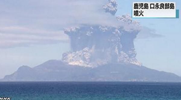
Kuchinoerabu - 29.05.2015 - photo Oh!kawa@カムバックパラダイス / Twitter
A violent explosive eruption marked the 29.05.2015 at 10am the Kuchinoerabu-jima island-volcano, accompanied by a plume rising to 9,500 meters (depending on the Tokyo VAAC) then drifting eastward, and a pyroclastic flow hurtling south-east to the coast.
The volcano has been placed on full alert level 5, and some 140 islanders evacuated.
This activity is from the Shindake cone, active since 1840.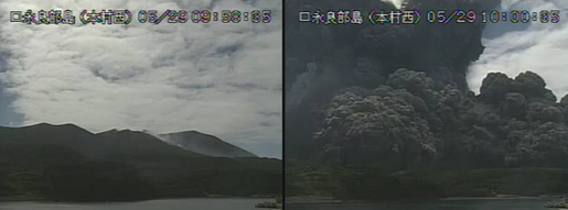
Kuchinoerabujima at 9h58 (before eruption) et 10 h00 (in eruption) 29.05.2015 - webcam of the volcano

Kuchinoerabujima 29.05.2015 / 10h04 pyroclastic flow - webcam of the volcano

Kuchinoerabujima 29.05.2015 / 10h06 - development of the eruptive plume - photo via Japan news
All airlines Japanese suspend their flights as a precaution to Okinawa and Southeast Asian (gmanews).
The Kuchinoerabujima experienced a similar explosion in August 2014 ... after which its alert level remained at 3.
The Kuchinoerabujima is a small island north of the volcanic Ryukyu archipelago, south of Kyushu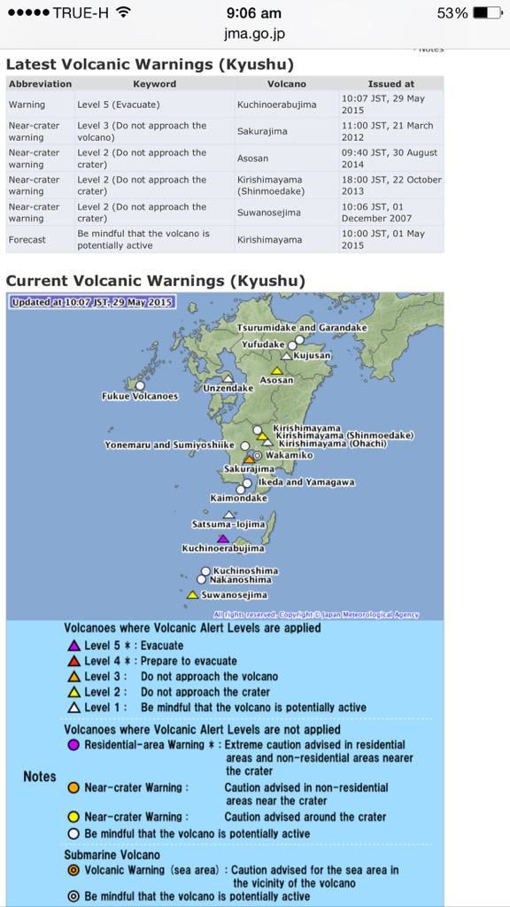
Sources :
- Médias locaux via Twitter
- VAAC Tokyo - link
- Geological Survey of Japan / Active volcanoes of Japan - Kuchinoerabu-jima
- Global Volcanism Program - Kuchinoerabujima
- JMA - Kuchinoerabujima
Partager cet article
7neoVendredi 29 Mai 2015 à 15:42"Salut neo, c'est le genre de sites qui frise mes neurones"...
les miennes aussi je te rassure,
mais bon il est parfois intéressant d'aller coir un peu ailleurs
ce que font les autres non?
6neoVendredi 29 Mai 2015 à 15:40Eruption au JAPON:
JAPON: Le volcan Kuchinoerabujima entre en éruption, le plus haut niveau d'alerte a été émis
 Les autorités japonaises ont ordonné vendredi l'évacuation des habitants d'une petite île du sud du Japon à la suite de l'éruption spectaculaire d'un volcan local.Quelque 137 villageois devaient quitter l'île de Kuchinoerabu, dans l'extrême sud du pays, à bord de bateaux affrétés par les gardes-côtes et la municipalité locale.L'éruption du mont Shindake - qui a commencé à 09h59 locales (00h59 GMT) - n'a fait aucune victime ni dégâts majeurs, selon un porte-parole de la police de l'île voisine de Yakushima.Des images de la télévision japonaise montraient une énorme colonne de fumée et de cendres s'échappant du cratère.Le Japon est situé dans la "ceinture de feu du Pacifique", une zone de séismes et de volcans.En septembre dernier, un volcan du centre du pays, le mont Ontake, était entré violemment en éruption et avait pris par surprise des promeneurs, faisant 57 morts et 6 disparus.
http://tvanouvelles.ca/lcn/infos/lemonde/archives/2015/05/20150528-223425.html
4neoVendredi 29 Mai 2015 à 15:333neoVendredi 29 Mai 2015 à 15:30Et celle là ,
tu en penses quoi ?
2neoVendredi 29 Mai 2015 à 15:27http://nsm08.casimages.com/img/2015/05/29//1505290325205626613311833.gif
j'ai oublié le Népal avec deux M ( 4.8 et 5.2 ) il y a 3H ...
ça ne t'évoque rien comme scénario Damien ?
1neoVendredi 29 Mai 2015 à 15:23Bjr tt le monde ,
comme convenu ,
je repasse par ici / actu EAU du jour :
M 6.8 en Alaska il y a 6h,
M 5.1 en Californie il y a 6h too
et M 5.2 à Atacama au CHILI
il y a 8h mtnt ...
et comme d'hab,
rien de tout celà aux infos de ce midi .
quelle belle presse nous avons mtnt !!!
je vous poste ensuite la carte,
le temps de faire les manips.
le gars avait donc partiellement raison /
EAU et alignements ...espérons donc que celà ne croisse pas en M
dans les heures à venir ,
sinon ,
tout serait encore manigancé amha
...
 Suivre le flux RSS des commentaires
 Ajouter un commentaire
Sarko nous a menés au bord du précipice. Avec Hollande, nous faisons un grand pas en avant.
-

-


-

-

-

Lever
06h00 UT
Coucher
17h15 UT
-


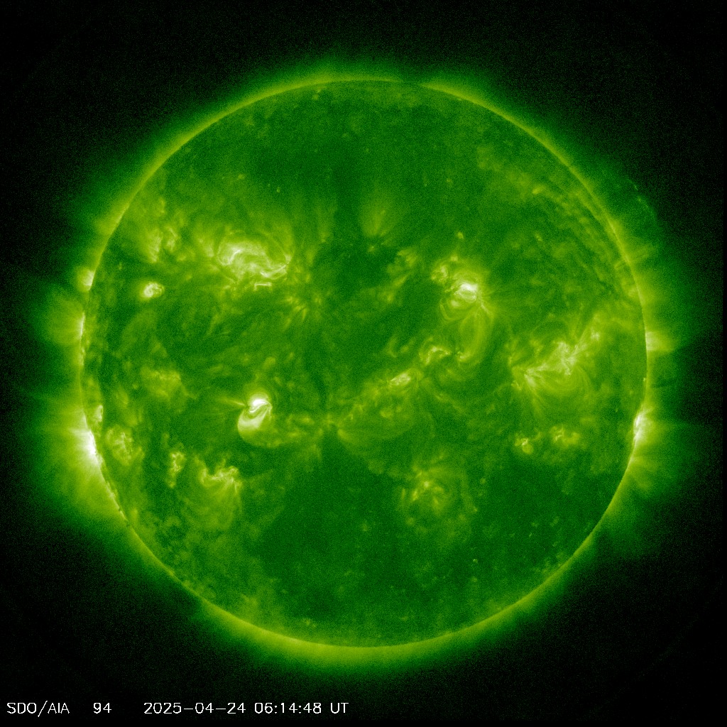
pour l'instant,
rien de neuf sous le soleil...